


Descripción de V-Navi
V-Navi - The full-featured navigation app for Android that brings you quicker to your goal! Works in conjuction with various apps (e.g., "Das Telefonbuch", "Das Örtliche", among others), even free of charge, as conditions may apply.
ATTENTION: Navigation can be started in Germany, Austria, Switzerland and optional in Western Europe.
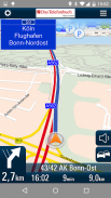
With the high quality traffic you will get a complete overview of the market. Traffic congestion traffic congestion avoidance. The V-Navi: you will thus always the best route. The traffic density is displayed in red, yellow, green in the map. Germany, Annual, 30 days free of charge with no obligation to buy. Internet connection is required.
The new version of V-Navi works with offboard maps (with limited functionality) to enable immediate navigation after download. The map data for Germany, Austria and Switzerland is downloaded once at the start of the first use of V-Navi (ca. 300 MB). Thereafter, an Internet connection is only necessary for a short time at app-startup.
HIGHLIGHTS:
- Current traffic situation in Germany (INRIX), traffic reports traffic congestion avoidance and traffic density display
- Offboard vector mode after first installation
- Lane info assistant
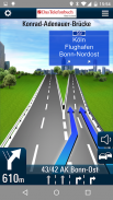
- Reality view (reality like display of turn actions on motorways)
- Map data is stored on the device
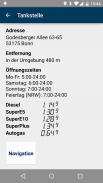
- Quick destination entry (address, points of interest (POIs), favorites, etc.)
- Updates free of charge
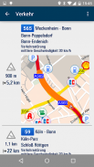
- Computation and display of alternate routes
- Display of speed limits and speeding alerts
- Support for portrait and landscape display
- Quick-Menu
- New and ergonomic menu
- Optimized map view
- Save & load itineraries
FUNCTIONS:
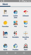
Destination entry:
- Address entry with an automatic pop-up list of cities, etc.
- Address search by country
- House-number-exact geocoding when online
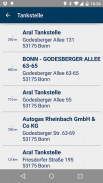
- POI search
- Destination selection directly on the map
- Entry of destination coordinates and crossroads
- Destination selection from a list of recent destinations and from the favorites list
- Use of contacts in the address book as destinations
Navigation:
- Profiles for car, pedestrians, recreational vehicles and caravans
- Adjustable routing: quickest, shortest
- Voice-guided navigation
- Spoken street names through text-to-speech
- Sinage display (motorway signs)
- Speed-dependent zoom and crossroad-zoom
- Stretch-block: Automatic route recalculation (e.g., for the next 0.5-10 km along the route to avoid a traffic jam)
- Avoidance of motorways, ferries, and tollways
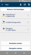
- Itineraries: Management of intermediate stops, saving and loading of itineraries
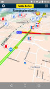
Map Display and Functionality
- View modes: 3D, 2D in the direction of travel, 2D North up
- Daytime and nighttime view modes, automatic switching (geodaylight)
- Route overview
- Display of POIs with setting of the destination directly from a POI icon on the map
CONDITIONS OF USE:
V-Navi may be used free of charge for a test period of 30 days. Numerous applications, such as the telephone directory apps "Das Telefonbuch" and "Das Örtliche" provide you with the means of continuing to use V-Navi free of charge by starting V-Navi directly from within the apps. Please consult the Conditions of Use in each of the respective apps.
The traffic data to 30 days (trial period) are free to use and are then as in-app purchase.
AVAILABLE in-app purchase options (for pricing, see under "In-App Purchases"):
- Traffic data for Germany (INRIX)
- Navigation und maps for Germany, Austria, and Switzerland (D-A-CH)
- Navigation und maps for Western Europe
The map data and navigation for Western Europe cover the following countries:
Germany (D),Austria (A),Switzerland (CH),Liechtenstein,Andorra,Belgium,Denmark,Finnland,France,Great Britain,Ireland,Italy,Luxemburg,Monaco,Netherlands,Norway,Portugal,San Marino,Spain,Sweden
See more at https://www.facebook.com/Map-and-Route-1454577274845960/
V-Navi - La aplicación de navegación con todas las funciones para Android que te lleva más rápido a su meta! Trabaja en conjunto con diversas aplicaciones (por ejemplo, "Das Telefonbuch", "Das Örtliche", entre otros), incluso de forma gratuita, como se puede aplicar condiciones.
ATENCIÓN: La navegación se puede iniciar en Alemania, Austria, Suiza y opcional en Europa Occidental.
Con el tráfico de alta calidad obtendrá una visión completa del mercado. La congestión del tráfico para evitar la congestión del tráfico. El V-Navi: se quiere, pues, siempre la mejor ruta. La densidad del tráfico se muestra en rojo, amarillo, verde en el mapa. Alemania, anual, 30 días de forma gratuita y sin obligación de comprar. Se requiere una conexión a Internet.
La nueva versión de V-Navi trabaja con mapas fuera del tablero (con funcionalidad limitada) para permitir una navegación inmediata después de la descarga. Los datos de los mapas para Alemania, Austria y Suiza se descarga una vez al comienzo de la primera utilización del V-Navi (aproximadamente 300 MB). A partir de entonces, una conexión a Internet sólo es necesaria para un corto tiempo en app-arranque.
REFLEJOS:
- Situación del tráfico actual en Alemania (INRIX), informa el tráfico para evitar la congestión del tráfico y la densidad del tráfico pantalla
- El modo de vector fuera del tablero después de la primera instalación
- Datos carril auxiliar
- Vista la realidad (la realidad como en la pantalla de acciones a su vez en las autopistas)
- Los datos del mapa se almacena en el dispositivo
- Breve introducción del destino (dirección, puntos de interés (POI), favoritos, etc.)
- Actualizaciones de forma gratuita
- Cálculo y visualización de rutas alternas
- Visualización de los límites de velocidad y alerta de exceso de velocidad
- Soporte para pantalla vertical y horizontal
- Menú rápido
- Nuevo menú y ergonómica
- Ver mapa optimizado
- Guardar y cargar itinerarios
FUNCIONES:
Introducción del destino:
- Dirección de entrada con una lista emergente automática de las ciudades, etc.
- Búsqueda de dirección por país
- Geocodificación Casa-number-exacto en línea
- PDI búsqueda
- Selección del destino directamente en el mapa
- Entrada de destino coordina y cruce de caminos
- Selección del destino de una lista de destinos recientes y de la lista de favoritos
- Uso de los contactos en la libreta de direcciones como destinos
Navegación:
- Perfiles para vehículos, peatones, vehículos de recreo y caravanas
- Encaminamiento ajustable: más rápido, más corto
- Navegación guiada por voz
- Hablado nombres de las calles a través de texto-a-voz
- Pantalla sinage (indicaciones de la autopista)
- Zoom y dependiente de la velocidad de cruce-zoom
- Estiramiento de bloque: nuevo cálculo de ruta automático (por ejemplo, para los próximos 0,5-10 km a lo largo de la ruta para evitar un atasco de tráfico)
- Evitar las autopistas, los transbordadores, y tollways
- Itinerarios: Gestión de paradas intermedias, el ahorro y la carga de itinerarios
Visualización del mapa y funcionalidad
- los modos de vista: 3D, 2D en el sentido de la marcha, 2D Norte hasta
- Durante el día y la noche vista modos, el cambio automático (geodaylight)
- Descripción de ruta
- Visualización de los puntos de interés con el ajuste del destino directamente desde un icono de PDI en el mapa
CONDICIONES DE USO:
V-Navi se puede utilizar de forma gratuita durante un período de prueba de 30 días. Numerosas aplicaciones, como las aplicaciones de telefonía de directorio "Das Telefonbuch" y "Das Örtliche" le proporcionan los medios para continuar el uso de V-Navi gratuitamente por iniciar V-Navi directamente desde dentro de las aplicaciones. Por favor, consultar las Condiciones de Uso en cada una de las respectivas aplicaciones.
Los datos de tráfico a los 30 días (período de prueba) son libres de usar y son entonces como la compra-app.
Las opciones disponibles de compra en la aplicación (para la fijación de precios, ver la sección "Compras In-App"):
- Los datos de tráfico de Alemania (INRIX)
- Navegación mapas und para Alemania, Austria y Suiza (D-A-CH)
- Navegación mapas und para Europa Occidental
Los datos de los mapas y de navegación para Europa Occidental cubren los siguientes países:
Alemania (D), Austria (A), Suiza (CH), Liechtenstein, Andorra, Bélgica, Dinamarca, Finlandia, Francia, Gran Bretaña, Irlanda, Italia, Luxemburgo, Mónaco, Países Bajos, Noruega, Portugal, San Marino, España, Suecia
Ver más en https://www.facebook.com/Map-and-Route-1454577274845960/
V-Navi - The full-featured navigation app for Android that brings you quicker to your goal! Works in conjuction with various apps (e.g., "Das Telefonbuch", "Das Örtliche", among others), even free of charge, as conditions may apply.
ATTENTION: Navigation can be started in Germany, Austria, Switzerland and optional in Western Europe.
With the high quality traffic you will get a complete overview of the market. Traffic congestion traffic congestion avoidance. The V-Navi: you will thus always the best route. The traffic density is displayed in red, yellow, green in the map. Germany, Annual, 30 days free of charge with no obligation to buy. Internet connection is required.
The new version of V-Navi works with offboard maps (with limited functionality) to enable immediate navigation after download. The map data for Germany, Austria and Switzerland is downloaded once at the start of the first use of V-Navi (ca. 300 MB). Thereafter, an Internet connection is only necessary for a short time at app-startup.
HIGHLIGHTS:
- Current traffic situation in Germany (INRIX), traffic reports traffic congestion avoidance and traffic density display
- Offboard vector mode after first installation
- Lane info assistant
- Reality view (reality like display of turn actions on motorways)
- Map data is stored on the device
- Quick destination entry (address, points of interest (POIs), favorites, etc.)
- Updates free of charge
- Computation and display of alternate routes
- Display of speed limits and speeding alerts
- Support for portrait and landscape display
- Quick-Menu
- New and ergonomic menu
- Optimized map view
- Save & load itineraries
FUNCTIONS:
Destination entry:
- Address entry with an automatic pop-up list of cities, etc.
- Address search by country
- House-number-exact geocoding when online
- POI search
- Destination selection directly on the map
- Entry of destination coordinates and crossroads
- Destination selection from a list of recent destinations and from the favorites list
- Use of contacts in the address book as destinations
Navigation:
- Profiles for car, pedestrians, recreational vehicles and caravans
- Adjustable routing: quickest, shortest
- Voice-guided navigation
- Spoken street names through text-to-speech
- Sinage display (motorway signs)
- Speed-dependent zoom and crossroad-zoom
- Stretch-block: Automatic route recalculation (e.g., for the next 0.5-10 km along the route to avoid a traffic jam)
- Avoidance of motorways, ferries, and tollways
- Itineraries: Management of intermediate stops, saving and loading of itineraries
Map Display and Functionality
- View modes: 3D, 2D in the direction of travel, 2D North up
- Daytime and nighttime view modes, automatic switching (geodaylight)
- Route overview
- Display of POIs with setting of the destination directly from a POI icon on the map
CONDITIONS OF USE:
V-Navi may be used free of charge for a test period of 30 days. Numerous applications, such as the telephone directory apps "Das Telefonbuch" and "Das Örtliche" provide you with the means of continuing to use V-Navi free of charge by starting V-Navi directly from within the apps. Please consult the Conditions of Use in each of the respective apps.
The traffic data to 30 days (trial period) are free to use and are then as in-app purchase.
AVAILABLE in-app purchase options (for pricing, see under "In-App Purchases"):
- Traffic data for Germany (INRIX)
- Navigation und maps for Germany, Austria, and Switzerland (D-A-CH)
- Navigation und maps for Western Europe
The map data and navigation for Western Europe cover the following countries:
Germany (D),Austria (A),Switzerland (CH),Liechtenstein,Andorra,Belgium,Denmark,Finnland,France,Great Britain,Ireland,Italy,Luxemburg,Monaco,Netherlands,Norway,Portugal,San Marino,Spain,Sweden
See more at https://www.facebook.com/Map-and-Route-1454577274845960/
V-Navi - Versión 4.9.7
(16-06-2020)
V-Navi - Información de APK
Version de la app: 4.9.7Paquete: de.mapandroute.android.vnaviApps en la misma categoría
Quizá también te interese...


